Environment Agency Objection Resolved Without Modelling — Eight Dwellings, Sileby

The challenge
Outline permission for eight dwellings on a 0.49 ha site behind Barrow Road was granted in December 2023. At that time the site was wholly in Flood Zone 1 — no flood risk assessment was needed and no flood condition was imposed. Then, in March 2025, the Environment Agency published its updated national flood map (NaFRA2), and the lower north-western part of the site was suddenly shown in Flood Zone 3.
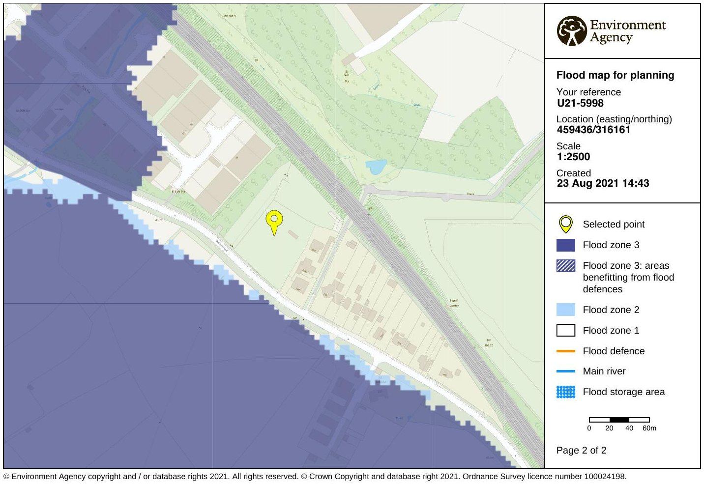
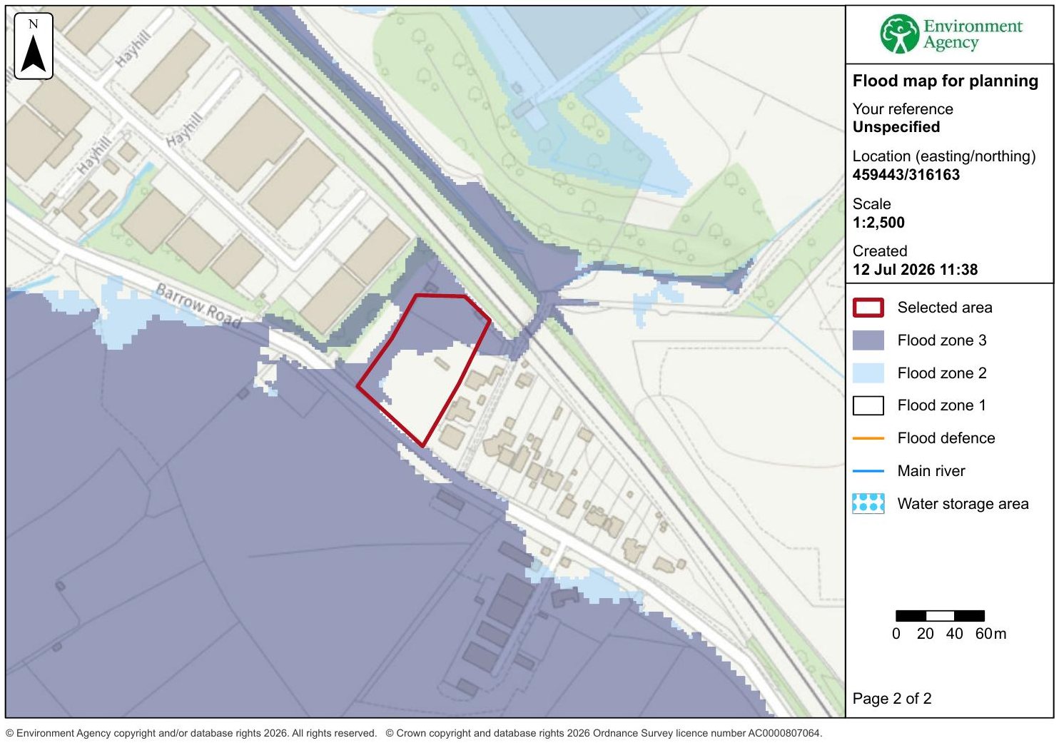
When the reserved matters application went in, the Environment Agency issued a holding objection. The developer faced the prospect of commissioning bespoke hydraulic modelling and providing on-site floodplain compensation — which, on a site this size, would have cost plots and made an eight-dwelling layout unworkable. The architect asked us to find a proportionate way through.
What we did
We started with the planning position rather than the hydraulics. Within a week of instruction we had written to the case officer and the Environment Agency setting out three points: the principle of development, including flood risk, had been established at outline when the site was in Flood Zone 1 and could not be reopened at reserved matters; the NaFRA2 mapping is a broad-brush national dataset that in this location represents an ordinary watercourse within the Lead Local Flood Authority's remit; and the Flood Zone 3b outline it had initially shown had already been withdrawn by the Agency owing to anomalies in the national data. Critically, the national model does not include the culvert that carries the watercourse away from the site under the adjoining industrial estate — so the mapped extent effectively shows a culvert-blockage scenario, a residual risk rather than a design flood.
Alongside that argument we offered a constructive way out: precautionary finished floor levels, set with freeboard above the maximum mapped flood extent. Two weeks later the Environment Agency confirmed, via the council, that it was willing to accept the raised floor levels provided they were expressed in metres above Ordnance Datum.
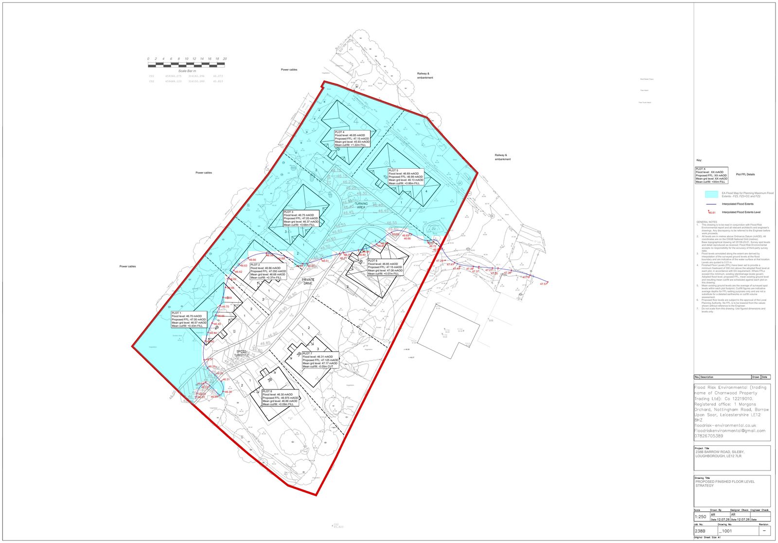
Deriving those levels is where the engineering sits. We georeferenced the maximum mapped extent — Flood Zone 3, Flood Zone 3 with the 2070–2125 climate change allowance, and Flood Zone 2 — onto the site topographical survey, which gave us around 290 spot levels to work with. The flood level along the extent was then read off as the surveyed ground level at the mapped water's edge, at 5 m intervals, with stations that tracked raised boundary features rather than open ground excluded. Across the site the interpolated flood level ranged from 46.14 to 46.85 mAOD.
For each plot we adopted the governing flood level at and immediately adjacent to it and set the finished floor level a minimum of 300 mm above — giving levels between 46.975 and 47.150 mAOD. Where existing ground or drainage levels were already higher, the higher level governed and gave extra freeboard. The result was an 11-page technical note and a single drawing that told the Agency exactly what it had asked for.
An eleventh-hour request
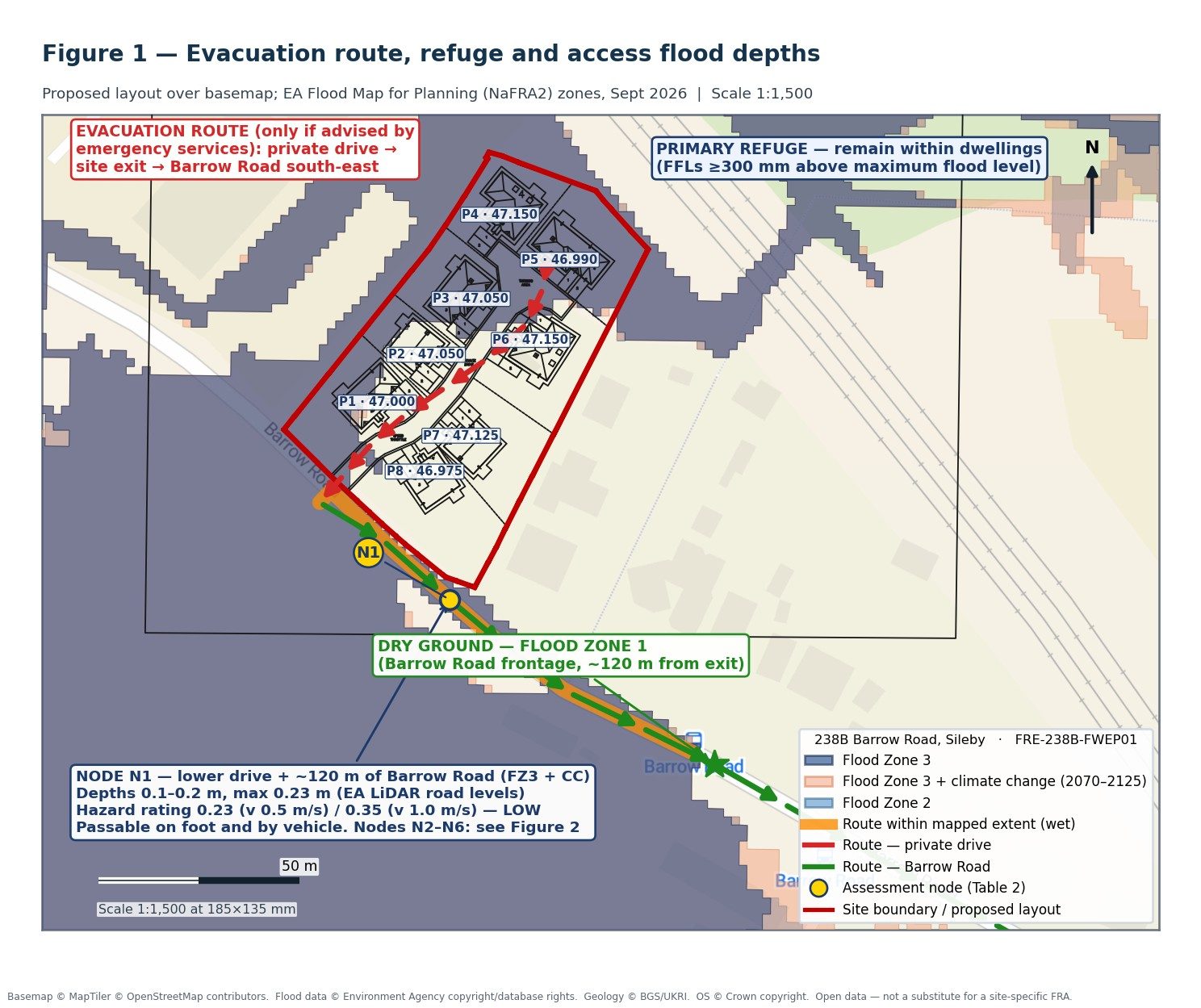
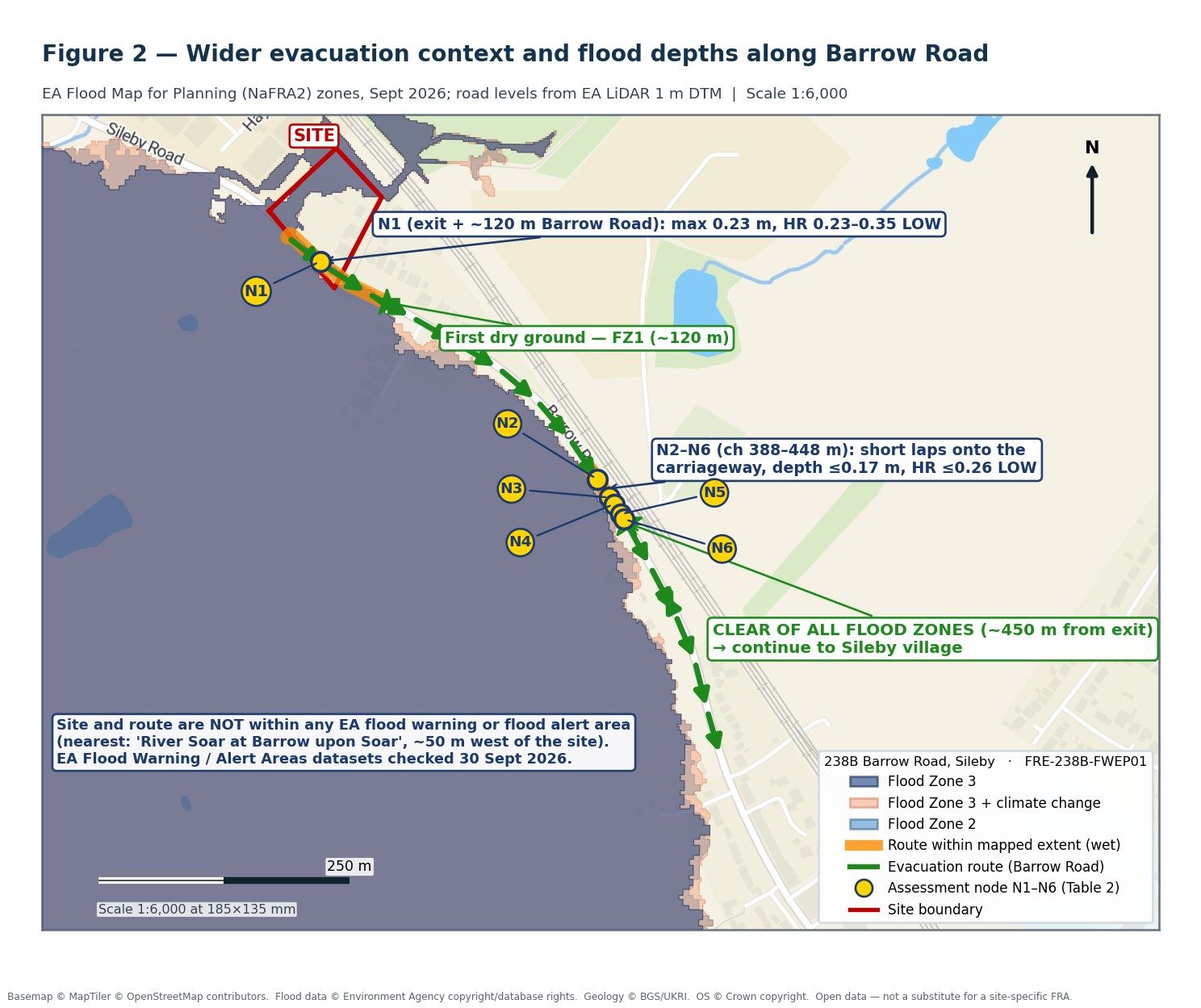
Two days before the decision was due, the case officer asked whether a flood evacuation plan existed. It did not — the Agency had not asked for one — so we produced a Flood Warning and Evacuation Plan the same day. It assessed the evacuation route along the private drive and Barrow Road against the mapped extent using the EA LiDAR terrain model, node by node: the maximum depth on the route was 0.23 m, every node scored a hazard rating below 0.75 ('low hazard — caution') and dry ground in Flood Zone 1 is reached about 120 m from the site exit. Because access and egress had been within the scope of our original fixed fee, there was no additional charge.
The outcome
The Environment Agency agreed to accept the precautionary floor levels as the means of resolving its objection, and the technical note supplied the levels it needed to withdraw it. No hydraulic modelling. No floodplain compensation. No lost plots. The applicant's exposure went from an open-ended modelling exercise to a fixed-fee note, a drawing and an evacuation plan, delivered inside the reserved matters timetable.
If you are in the same position. The March 2025 NaFRA2 map moved thousands of sites into Flood Zone 2 or 3, and objections like this one are now common on applications that were once straightforward. The answer is rarely bespoke modelling. It is usually a clear account of the flood mechanism, a proportionate mitigation the Agency can accept, and levels it can check. We have done this before and we can usually tell you within a day whether it will work for your site.
Related services
All Services & Resources
Everything you need for flood risk, drainage and environmental planning consultancy across England and Wales.
Flood Risk
Drainage
Other Services
Areas Covered
Frequently Asked Questions
Need a Flood Risk or Drainage Consultant?
Planning-ready FRAs and SuDS drainage strategies across England and Wales. Free quote within 24 hours.
Get a Free QuoteOr contact us directly: 07826 705389 •