Six-Storey Mixed-Use Scheme on a Surface Water Flow Path — FRA and Drainage Strategy, Elland

The challenge
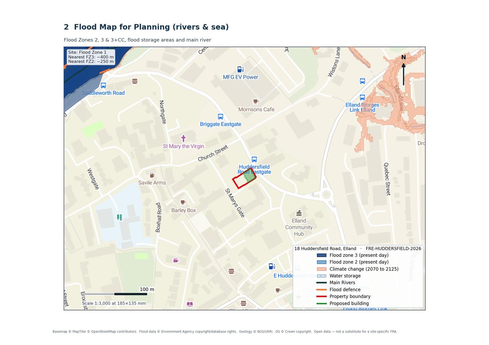
The site is 20–25 m above the River Calder and comfortably in Flood Zone 1, so the sequential test is passed without argument. Surface water is another matter. The Environment Agency's surface water map shows a flow path entering from the higher St Mary's Gate side, crossing the existing undrained car park and reaching the footprint of the proposed building, at depths of 600–900 mm in the 1 in 1,000 year event and the 1 in 100 year event with climate change. On a 0.0535 ha plot, with ten apartments above two ground-floor commercial units and a car park to fit in, there was nowhere to hide from it.
Calderdale, as Lead Local Flood Authority, also requires its surface water drainage pro forma to be completed at outline stage, and there was no topographical survey, ground investigation or infiltration testing yet.
What we did
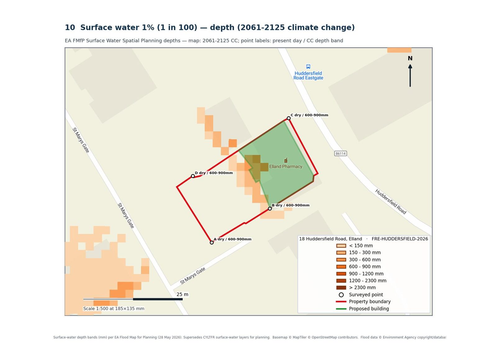
We produced a 14-plan open-data map series — flood map for planning, surface water extents and depths for three return periods with climate change, historic flooding, warning areas, geology — so that every claim in the report could be seen rather than asserted. Then we dealt with the flow path by design.
The car park becomes permeable paving draining to on-site storage. A linear drainage channel along the rear face of the building intercepts residual flow before it reaches the elevation. Proposed levels grade the car park to the southern boundary, and the overland flow routes on the drawings direct any exceedance onto the lane to the south and down to Huddersfield Road, away from the building. Finished floor levels sit a minimum of 150 mm above external ground, and all habitable accommodation is at first floor and above — so the ground-floor commercial units are the only floor space in contact with the flow path, and they are protected by levels, interception and routing.
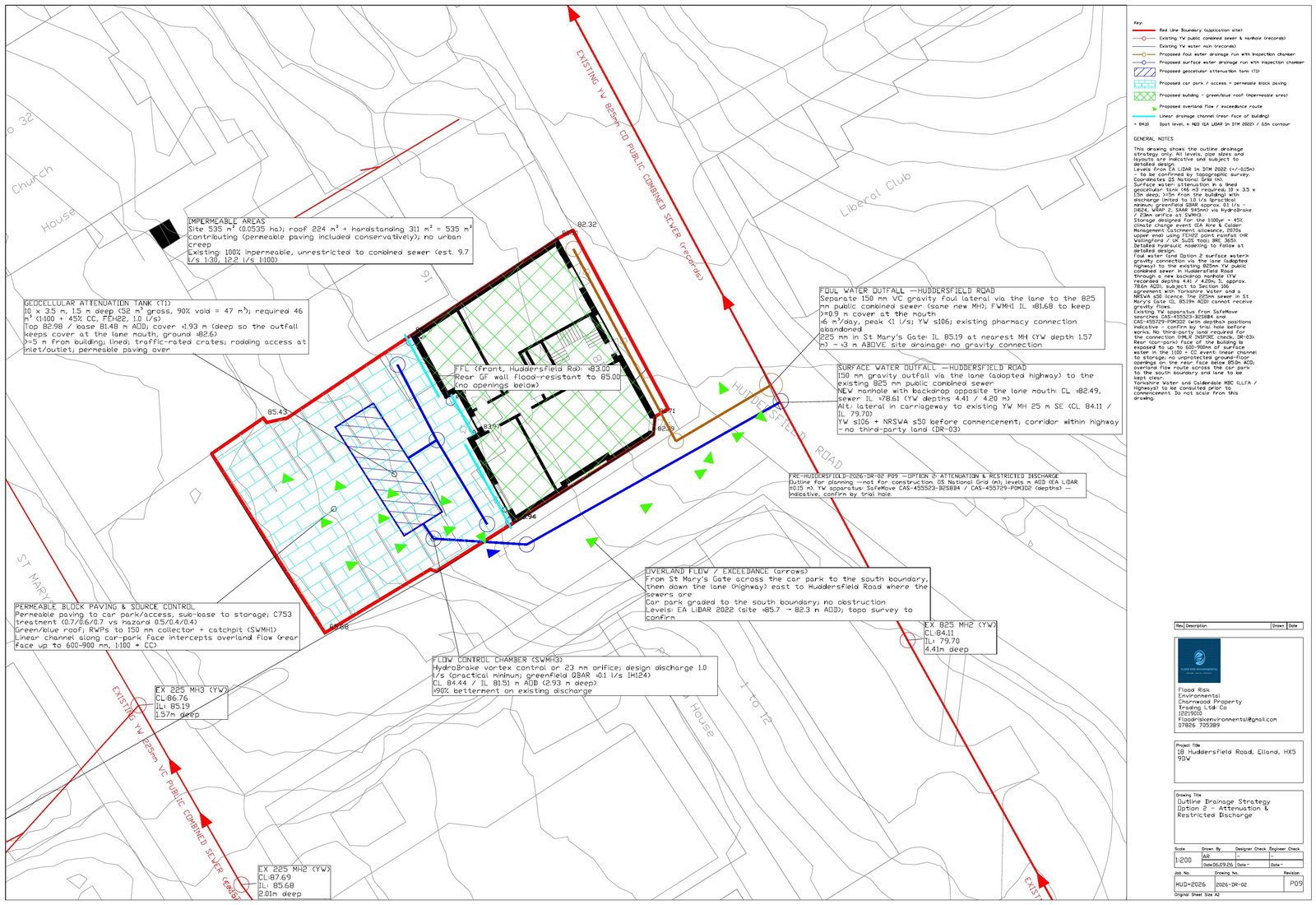
The drainage strategy follows the hierarchy with two options carried in parallel. Option 1 is infiltration: BGS mapping shows permeable Rough Rock sandstone at or near the surface with no clay cover, so a geocellular soakaway is the preferred route, to be confirmed by BRE 365 testing at detailed design. Option 2 is a lined attenuation tank with a vortex flow control restricting discharge to 1.0 l/s to the combined sewer, using Yorkshire Water's georeferenced asset records. Green or blue roofs, rainwater harvesting and the permeable car park provide source control and treatment in both. The design allows for the Environment Agency's upper-end +45% peak rainfall allowance for the Aire and Calder catchment over a lifetime to 2125, and the pro forma was completed line by line from the strategy.
The outcome
An outline submission that turns the surface water flow path from a reason for refusal into a set of design commitments the reserved matters scheme has to honour: levels, an interception channel, permeable parking, exceedance routes and a drainage hierarchy with the evidence for each step. The applicant knows exactly what testing is needed before detailed design, and the LLFA has its pro forma answered from the outset.
If you are in the same position. A surface water flow path across a tight urban plot is a design problem, not a reason to abandon the scheme. It is solved with levels, interception, permeable surfaces and an honest exceedance route — and by giving the LLFA the evidence it asks for in the format it asks for it.
Discuss a flood risk and drainage strategy for a development site →
Related services
All Services & Resources
Everything you need for flood risk, drainage and environmental planning consultancy across England and Wales.
Flood Risk
Drainage
Other Services
Areas Covered
Frequently Asked Questions
Need a Flood Risk or Drainage Consultant?
Planning-ready FRAs and SuDS drainage strategies across England and Wales. Free quote within 24 hours.
Get a Free QuoteOr contact us directly: 07826 705389 •